Weather and Air Traffic Control
Weather plays a major factor in the traffic capacity of a runway; rain, ice, snow, etc. result in longer landing times due to the rate of slow and exit which in turn results in greater required space between aircraft landings. Similarly, fog results in a decrease in landing weight. Both of these result in the need to establish a safe holding pattern in which aircraft must remain until there is space for them to land safely.
Thunderstorms cause many hazards to aircraft and thus must be avoided. Because the area effected by a thunderstorm must be avoided by the aircraft, the capacity of the en-route system is then reduced and more space per aircraft is required or congestion results from numerous aircraft trying to clear the same storm.
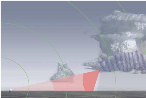
Thunderstorms are possibly the most dangerous threat to aircraft for several reasons: they are extremely common, they are difficult to see from the cockpit, and they can contain heavy rain, strong wind shear, large hail and severe turbulence, all of which can damage or destroy aircraft. ATC uses radar to detect such storms; a pulse of microwave energy is broadcast in a specific direction and that energy is bounced back when it collides with an object. Radar equipment detects the reflected energy and measures the elapsed time; these pieces of information provide the distance to the object. The strength of the reflected signal would indicate the solidity and size of the object and then computers translate the data into images.
Despite the value of the use of radar to detect weather conditions, there are certainly limitations. While radar can detect precipitation, which is helpful, it cannot detect clouds in which precipitation is absent and thus cannot be used in all situations to warn pilots of situational dangers. Similarly, radar cannot detect turbulence. Radar also has limits to the altitudes in which it can be used; if terrain blocks the radar signal it is rendered useless: think mountain regions.
Airport Surveillance Radar and the Weather and Radar Processor
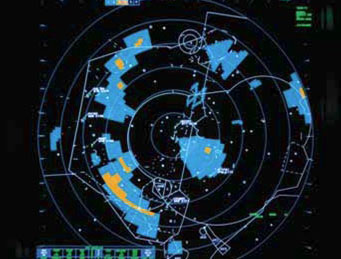
Airport Surveillance Radar (ASR) and the Weather and Radar Processor (WARP) are two different radar systems which can be used to provide information to pilots. This system is only used in
Airport Surveillance Radar data is transmitted from the radar station to the controller and there is little to no lag time involved so pilots can receive the most up to date weather information using this system. Additionally, newer versions of ASR equipment can provide controllers with precipitation intensity which is valuable information to any pilot.
Restrictions to this system are the same as any other ground based radar system: it only detects precipitation and coverage is limited at low altitudes or in mountainous areas
.
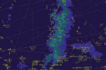
The Weather and Radar Processor takes data from multiple Next Generation Radar sites and overlays the data on one scope; WARP is used specifically in en-route control centers. The largest limitation of the WARP system is that it cannot read light precipitation levels, only moderate, heavy and extreme which means that a controller using it may not be able to provide a warning before the conditions become hazardous. Another limitation of WARP is the time delay associated with the information; because the information is gathered from multiple sites and then compiled, it is generally up to 6 minutes old when the data/image becomes available.
Additionally, WARP cannot provide information on the altitude at which precipitation is occurring; the only way a controller would be able to provide useful information on precipitation tops would be if secondary clues are being provided by pilots in that area in the form of altitude change requests, turbulence reports, etc.
While air traffic controllers can provide high quality weather information to pilots, their first priority is to separate traffic. A pilot can always request a weather advisory but a controller may be too busy to provide adequate information.
Instrument flight rules are a set of regulations and procedures used to fly an aircraft using only the instrument panel for navigation. Using these, a pilot can fly an aircraft even if he cannot see anything out of the cockpit windows; pilots flying under IFR are authorized to fly through clouds. A vital concept of IFR flight is the maintenance of separation from other aircraft in any weather condition. IFR flights are monitored via radar by air traffic controllers when it is available or by aircraft position reports when it is not. IFR flights that are in controlled airspace require clearance from an air traffic controller for each portion of the flight; each clearance will include a clearance limit, indicating to the pilot how far he may continue without a new clearance.
IFR is important when aircraft operate in Instrument Meteorological Conditions (IMC); weather is considered IMC when the minimum requirements for Visual Meteorological Conditions are not met. In such conditions where an aircraft is operating in IMC, the pilot will fly the craft relying on flight instruments while ATC provides separation from other aircraft.
Visual flight rules are regulations allowing a pilot to operate an aircraft in favorable weather conditions: or weather conditions clear enough to allow him to see where the aircraft is going. In order to fly under VFR, a set of minimum requirements must be met; the pilot must be able to see outside of the cockpit, control the aircrafts attitude, navigate, and avoid obstacles and other aircraft. A flight operating under VFR must also maintain a specific distance from clouds and be operating in an environment meeting minimum visibility requirements.
Air traffic control is only required to maintain separation between aircraft operating under IFR, however they will, workload permitting, assist pilots flying VFR. When ATC does assist VFR flights, it is on an advisory service only and the pilot remains responsible for maintaining separation from other aircraft and navigating the aircraft properly.
In the United States a VFR flight is not permitted in Class A airspace which extends from 18,000ft to 60,000ft.